Friday, December 30, 2011

Big lake effect snow is on the way for 2012

A blast of Arctic air is heading our way and will arrive on Sunday to kick off the new year. While it's not a terribly cold arctic air mass, it will certainly be the coldest we've seen this season with daytime highs early next week in the low to mid 20s and wind chills at times in the single digits. But, the big news with the cold air will be the return of real, live lake effect snow. Yes, a significant lake effect snow is likely beginning late Sunday.
Here's the scenario as it looks now...
The cold front ushering in the Arctic air mass will arrive during the day Sunday.  Once that air gets in place lake effect snow will start to develop. This will continue through Sunday night, but then on Monday, the winds are expected to shift more northwesterly and that will really ramp things up.  Right now it looks like 4-8 inches of snow will fall Monday and Monday night.  The lake effect will continue on Tuesday, but begin to back off toward evening.
One more note...this is NOT the beginning of a 20-day stretch of cold air.  By the end of next week we will be back in the lower 40s for daytime highs.
Patience my winter snow friends!

Wednesday, December 28, 2011

New Years Eve looking good

Well, we had our few inches of snowfall and that should get us through the rest of 2011. We'll have a mix of rain and snow off and on Thursday and Friday, but the good news is that New Years Eve is looking pretty decent. During the day Saturday we should have lots of sun with some clouds mixed in as well.  If you are going to be out celebrating the turning of the calendar, perhaps down in Akron at First Night, you can expect partly cloudy skies with temperatures in the mid 30s. It will be a tad breezy so the wind child will be in the mid to upper 20s, but still, not bad for December 31st. Enjoy!

Tuesday, December 27, 2011

Finally!

Well, it looks like we are finally going to see some snow. A storm system heading up the Appalachians will scoot to our southeast today dumping a couple of inches of snow before lake effect sets up tonight. We are looking at 2-4 inches of new snow by Wednesday morning with perhaps another inch before it ends around midday. It won't be much, but at least it will be a start. It's also probably going to make driving a bit difficult tonight, so watch out for those people who forgot how to handle snowy roadways.

Friday, December 23, 2011

I'm dreaming of a non-white Christmas

In case you haven't accepted it yet, what we were saying it going to come to fruition. There will be no white Christmas for us this year.  The best we can do is to maybe late Christmas Day bring in some flurries and snow showers. There will be nothing around to build a snowman or sled ride on. Actually most all of the country, except for the Rockies and the upper states of New England, will have a non-white Christmas this year.  This is in great contrast to last year when over half the nation was covered with snow. My, what a difference a year makes.  Meanwhile, from all of us to all of you, best wishes for a Merry Christmas and a happy holiday season.

Tuesday, December 20, 2011

A mini-White Christmas?

The forecast models are getting interesting as we head into the Christmas weekend. Most of the models are calling for a rather "light-weight" storm producing a rain/snow mix across NE Ohio. However, there is one train of thought that could maybe give us a couple of inches of snow Saturday night into Christmas day. It's too early to know for sure right now which way we will go, but at least there might be hope for a couple of inches. Ho, ho, ho! More later.

Wednesday, December 14, 2011

A white Christmas? Probably not...

Well, as we were thinking, the chance of a white Christmas is not looking very good.  Of course, that is determined by what you call a white Christmas.  Is it snow on the ground Christmas Day, or snow falling on the holiday, or snow falling a few days before Christmas?

Here's what we are looking at for next week...Christmas week. We should see continued above freezing daytime highs throughout the week, but when we get to Christmas Eve, temperatures will likely cool down and there could be some snow. At this point it doesn't look like much, but it might satisfy your personal needs. We'll know more as we get closer to the end of next week.

Meanwhile, below is a map our friends at AccuWeather released indicating the chances of a white Christmas nationwide. As you can see, it's doesn't look good for NE Ohio.


Sunday, December 11, 2011

(Insert YAWN)

I wish there was something exciting to talk about, but there isn't. We remain pretty much in this same weather pattern we have had for quite some time.  No real arctic air is breaking loose and heading into the Great Lakes to stay. During the period between now and Christmas it appears that no significant change will take place. There will be quick shots of colder air coming through and some light-weight snowfall, but, as for cold air coming to camp out and snow storms and winter stuff like that, I think not. The normal highs during the next few weeks should be in the mid 30s. We will be near or above that most of the time. Unless we can get a cold shot right before Christmas, I don't think our chances are looking good for a white Christmas...and if it is white, it won't be very white..maybe just a few inches.

Thursday, November 17, 2011

On Wednesday evening I participated in a winter wether webinar with AccuWeather, Senior Expert Meteorologist, Henry Margusity. During the session we discussed this upcoming winter and what we might expect.

Bob Long at the AccuWeather winter weather webinar.
To start, this is going to be a tough forecast.  Long-range forecasters like to look at the past and find years that had similar patterns to the current and then see what happened, then base a forecast off of that.  Well, this year has been unique. In fact, some forecasters say that they can't really find anything that matchs up to the extreme weather we have had this year...for example the October snowstorm along the east coast and in New England and now the unusually warm November.

A few months back we were looking for the cold air to drop into the region right around Thanksgiving and then hang out for several months. It was going to be really cold for a long period of time. It was also going to be quite a snowy winter. That thought seems to have changed a bit. It looks now like the colder air will not be coming in until early to mid December. Margusity says, however, not to expect the cold air to drop in and stay.  He also thinks our area will get some good lake effect snows, but that whether it be lake effect or synoptic, the snow will be "here today" and then "gone in a day or two."  In other words, it will get cold and snow and then warm up a few days later causing the snow to melt. He thinks we could still have normal to slightly above normal snowfall in NE Ohio, but it will have to begin by mid-December for that to happen and that's not a certainty.

As for the usual winter clippers and other synoptic storms, expect most of the snowstorm activity to be in the western Great Lakes, perhaps even west of Chicago and along the east coast.

When it is all over, Margusity says that the record books may show that we had a fairly hard winter, but emotionally - because of the ups and downs - we will likely be saying, "You know, the winter really wasn't that bad."

So, there you have it.  I caution you however, this has been a strange year weatherwise, and you can't rule out anything during the next several months.

Sunday, November 13, 2011

Up and Down...and, Up and Down...

Temperatures this week are going to be fluctuating a lot again.  Similar to last week, we will start off mild and then turn colder mid-week followed by a slight warmup for next weekend.
Thanksgiving week is still a bit up in the air at present. The computers are giving us mixed messages. We could get a hefty shot of cold air surging into the lower lakes around the holiday, or things could stay the way they have been. It looks like any "permanent" push of cold air, though, is still a ways off.

Thursday, October 20, 2011

Another cold and snowy winter forecast

The National Weather Service issued its winter forecast today. The "good" news is that it goes right along with what we told you to expect in an earlier post.  It is likely to be cold and snowy this winter. If you look at the map to the left you will see that NWS expects us to have a greater than 40% chance of above normal snowfall. In addition, they say we have a better than 33% chance of colder than normal temperatures. Woo hoo! Winter sports enthusiasts will love this!

Here's what we posted earlier in the month:

  • Lake effect snow will begin in mid to late November and continuing into early January.
  • The coldest time period should by from around Thanksgiving until just past New Years.
  • The snowiest period should come during January and February.
  • Expect frequent clipper storms to move through the lower Great Lakes.

Sunday, October 9, 2011

A few more days, then back to cool and wet

A cold front over the western Great Lakes midweek will
make its way into eastern Ohio late in the week and bring
with it breezy conditions, cooler temperatures,  and showers.
The nice, sunny, above normal temperature weather will continue through midweek, then a change to more Fall-like weather will occur.

Upper 70s to around 80 degree daytime highs will hang around through Tuesday.  We will start a slide downward on Wednesday with highs only in the mid-70s, then a bit cooler on Thursday, and much cooler on Friday. Friday's high will be in the low to mid-60s with even cool highs for the weekend. Toss in some late week and weekend showers and it will be a return to Fall.

So, enjoy these next few days.

Thursday, October 6, 2011

Let's take a look at Winter

The winter predictions are starting to come out. One of the first comes from AccuWeather's Long Range forecaster Paul Pastelok. According to Pastelok, we will see a lot of lake effect snow in the area this year. He also sees above normal snowfall for the region in part do to frequent clipper storms moving through the lakes. The heaviest snow, he predicts, will be in January and February. The coldest part of the winter will be from around Thanksgiving until just past New Years, but on average we should be near normal for the winter season.

Here are the bullet points of Pastelok's forecast:

  • Lake effect snow will begin in mid to late November and continuing into early January.
  • The coldest time period should by from around Thanksgiving until just past New Years.
  • The snowiest period should come during January and February.
  • Expect frequent clipper storms to move through the lower Great Lakes.
So there you go.  The first look is for above normal snowfall with temperatures averaging about normal.

Sunday, October 2, 2011

Relief is on the way!

If it got too cold too quickly for you, relief is on the way! After we get past Monday, conditions are going to improve considerably.  In fact, it's going to be a very nice fall week. Temperatures will average around normal in the upper to mid 60s and some days even higher than that. All that with lots of sunshine! So, just hang in there through Monday and life will be good.  :-)

Wednesday, September 28, 2011

Cold air and a Fall-like weekend

(Map courtesy of Accuweather)
The coldest air so far this season is going to drop into the region for the weekend.  Cold front number one will cross over Thursday evening. A second cold front will push through on Friday evening and after daytime highs in the mid 60s on Thursday and in the upper 50s for Friday, we will see highs only around 50 on Saturday.  Combine that with a stiff NW wind and lake effect rain showers and it's going to be a rather cold and damp couple of days.
Friday night football is going to be what I call "dog nose" weather...cold and wet so make sure you bundle up if you are going out.

Sunday, September 25, 2011

Not much going on

There's not been a whole lot of exciting weather going on the past few weeks.  Aside from a lot of rain, with more to come, it's been a rather uneventful time. No complaints here.  But, now that fall has officially arrived, I suspect we can start to look for Mother Nature to throw us some radical mood swings. I don't see anything bizarre in the next few weeks, just some roller coaster temperatures from the 70s to the 60s. Typical fall stuff. When the winter storms start forming, that's when we'll have fun!

Monday, September 12, 2011

Is that the sun I see?

Wow!  Monday morning and the sun is shining!  It's been a while since we have seen clear skies with sunshine. Finally the remnants of that upper level storm from last week have moved away.  That's going to allow us to have a couple of nice days before colder air and clouds move in midweek.

Temperatures today (Monday) and tomorrow will be around 80. That's just a tad above the normal daytime high of 75. But, don't get too excited.  Two cold fronts will cross the area this week, one late Tuesday and another on Wednesday, knocking daytime highs back into the 60s. In fact, we could see overnight lows dipping into the 40-45 degree range on Thursday and Friday mornings.  Ooooo!  The chill of Fall.

Saturday, September 3, 2011

Labor Day looks cool and damp; tropical rain later?

As I mentioned earlier, Labor Day was going to be cool. It looks like it's going to be even cooler than first thought. The daytime high temperature will top out just below 70. And, the rest of the week will see highs of 70-75. I'm ready for that after the 90s on Friday and Saturday. Didn't we already do like twenty days of that in July? Oye! Later in the week, we may also get some rain from Tropical Storm Lee. At this time that storm is meandering off the Gulf coast. It should move inland over the holiday weekend and then head northeast. Exactly where is will go is still uncertain, but several of the long range forecast models have the storm center heading heading up the Ohio valley mid to late week. If that happens, we will at least have lots of clouds and depending on the track some significant rain, too. More on that later. Meanwhile, enjoy your holiday and dodge the showers when you can.

Wednesday, August 31, 2011

The Labor Day Weekend

It's going to be a variable holiday weekend around NE Ohio. Before we even get to the weekend, July-like heat is going to be heading back into the region. High temperatures Thursday will be in the upper 80s. On Friday we may top 90. Saturday will be back into the mid to upper 80s. Then we start to cool down. The high on Labor Day (Monday) will be in the 70-75 degree range. It should be a very pleasant holiday to be outside.
I think the first half of September is going to be very nice as well. The long-range forecast is calling for temperatures to generally hang around the low to mid 70s most days. Precip should be normal.

Friday, August 5, 2011

A nice break next week

If you are tired of the heat, you'll enjoy what's in store for us next week. Our upper atmosphere pattern is going to change and the hot, sunny weather we have had for the past several weeks is going to shift into a more progressive pattern with frequent intervals of clouds and showers. Along with this shift will come cooler temperatures. Daytime highs next week will be near normal meaning around 80 degrees rather than 90.

Me thinks I'm looking forward to that.  Enjoy!

Friday, July 22, 2011

I thought August was supposed to be hot

When I was growing up, it always seemed that August was the hotest month of the summer.  Remember the line "the dog days of August?" Seems that July is in the race this year. Yesterday (Thursday, 7/21) we topped out at 97 at the Weather Center. Cleveland Hopkins tied their record set in 1952 with a 97.  Toledo blew their record out of the water.  The old high was 99 in 1930.  They beat it by three maxing out at 102 degrees.

For us, the worst of the heat is over for now.  We are still going to be well above normal and the mercury will still flirt with 90 from time to time, but the 95+ temperatures have left the building, hopefully for the remainder of the summer.

This weekend is going to be warm...around 90 both days...but, then will we cool down a tad into the mid 80s for a few days.  It does look like another mass of hot air will push through the area late next week and into the weekend, but it will not be as prolonged or as hot as this one was...just lower 90s. (Actually, I'm waiting for nighttime lows to drop back into the lower 60s and upper 50s. That's makes for a very pleasant morning.)

Anyhow, enjoy what's left of July.  The outlook for August is for normal temperatures, so there is some relief coming down the pike about the second week of the month.

Saturday, July 16, 2011

Warm and wet since April

I thought I would go back and take a look at temperatures and precip and see what has happened so far this year.  The bottom line is that since February we have had above normal precipitation and since April temperatures have been warmer than normal.

As for the rainfall/snowfall category, we have averaged more than 150% above normal from February through June. That's wet.  So far, though, July is running below normal.  We are halfway through the month with only 1/3 our normal rainfall.

Temperature-wise, March was last month when the mercury averaged below normal. From April through mid-July we are running +2.65 degrees.

Here's the breakdown:

Month        Temperature Departure     Precip % of Normal

February               - 0.1                                  194%
March                   - 1.3                                  141%
April                     + 2.8                                 146%
May                      + 3.5                                 183%
June                      + 1.6                                 152%
July (thru 7/15)          +2.7                                    33%

As for the future, it looks like temperatures will remain well above normal through the end of July. Things will return more to normal in early August and probably remain there into Fall.

Wednesday, July 13, 2011

It's gonna get hot, hot, hot!

(Graphic courtesy of  Accuweather)
July heat is on the way and it's going to start moving into the region this weekend.  An upper level high pressure system will move into the midwest and that's going to clear skies and the heat that has permeated the southwest this week is going to head east.  There's some debate on exactly how hot temperatures are going to get, but I would expect to see the mercury up near 90 higher every day next week. We could see a day or two in the upper 80s if some "dirty clouds" move into the region, but most of that is expected to stay south of here.

So, enjoy the rest of this week because once we hit the weekend it could be very toasty for the rest of July.
(Remember spring?  LOL)

Friday, July 1, 2011

4th of July looks pleasant

(Map courtesy of www.accuweather.com)
As we head into the holiday weekend, the weather seems to be cooperating. Saturday will probably be the least desirable day of the three, but even that won't be too bad.

A cold front is going to push through the area Saturday night/Sunday morning.  Out ahead of it on Saturday it's going to be hot and muggy.  Temperatures will top out round 90 with the dew point up around 70.  Yuk!  We'll also mix in a few isolated thunderstorms.

That whole package will move out by midday Sunday and the rest of the holiday looks good. Temperatures on Sunday and Monday will be in the 80-85 degree range with lots of sun and much lower humidity.

Best wishes for a happy 4th of July weekend.

(BTW...stop and see us Saturday from 9am-5pm at the Kent Heritage Festival and Monday in the Stow Fourth of July Parade.)

Thursday, June 23, 2011

Not much going on

So my sister is yellng at me for not updating my blog for almost a month. She's right, of course. Lol

Well since the spring floods there just hasn't been much going on. Once we get into heat waves, droughts, and hurricane fun, I'll update more often.

Till then, just enjoy.

Friday, May 27, 2011

We've earned a nice weekend

Following a crazy late week bunch of storms, it looks like we've earned ourselves a nice holiday weekend.

Enjoy!

Saturday
Some morning clouds with afternoon sun. Showers are possible overnight.
High 77

Sunday
A mix of couds and sun with a chance of a left over morning shower.
High 83

Monday
Mostly sunny.
High in the upper 80s

Wednesday, May 25, 2011

After all this...it looks like a nice holiday weekend!

Wow...we're gonna get lucky.  After a week of clouds and rain, the holiday weekend is actually shaping up to be rather nice. Probably won't be 100% dry..some showers will perhaps float through during the overnights, but for the mot part we should be pretty decent.

Saturday - A mix of clouds and sun.  High 75-80

Sunday - Lots of sun. High 85

Monday (Memorial Day) - Mostly sunny.  High 80-85

Enjoy!

Monday, May 16, 2011

"Dog Nose" weather continues...cool and wet

The long range forecast for the next 30-days is not all that promising if you are waiting for sunny, hot weather.  The 30-day forecast for mid-May to mid-June (see maps below) is calling for temperatures to average below normal with rainfall above normal.

This cold pattern we are in now will break by the end of the week, and while we will likely hit the upper 70s and lower 80s for a few days next week, a some daytime highs in the 60s are still going to be around until the end of the month.


Sunday, May 15, 2011

Right back into that old wet pattern

So, here we are again...stuck in a cloudy and wet pattern. It moved in late last week and will continue with us for much of this coming week. Upper level instability will give us the chance of showers almost any time between now and Thursday. It's really hard to predict exactly when the rain/showers will move in. They'll just happen like they did over the weekend.

Temperatures will be rather cool this week as well. Our normal daytime high is around 70. We won't see that until later in the week.

We are stating to get a hint at the summer forecast. So far, it doesn't look good for lower Great Lakes region (that's us). The trend seems to be for a cool and damp summer. More on that later.

Saturday, May 7, 2011

Things are turning...for the better...finally!

Ah finally, it looks like we are getting out of this weather funk we've been in for the past month and a half. Temperatures are going to be pretty nice this coming week. We are looking at 70s and perhaps even 80 through midweek. We will have some clouds with occasional showers possible almost any time after Monday, but for the most part theses should be scattered.

As we get to the end of next week, another cold surge is coming down from the north. Looks like weekend highs will be in the low 60s next weekend, but then should rebound into the low 70s to start the following week (week of May 15).

While the mid 60s and lower 70s are not what a lot of you would like to feel, I'll take it. I've had it with those daytime highs in the 50s.

Enjoy!

Tuesday, May 3, 2011

Well, there is some good news

After I depressed most of you with my last post, here's a bit of good news. After we get past mid-week this week, temperatures will start to warm. We will likely see daytime highs in the 60s Thursday through the weekend, then actually warm up into the 70s for next week.  But, as I mentioned before, don't get too excited.

The following week, around May 16, temperatures are likely to drop again to normal or slightly below.  By that time normal daytime highs will be in the upper 60s to around 70, so even at that it won't be terribly cold. However, we will once again have to watch out for fast moving rain systems.

Slowly we are getting warmer...but, not drier.

Sunday, May 1, 2011

Could May be like April? Yes it could!

I'm not liking what I'm seeing and reading. There is a real possibility that this cool, wet weather pattern could  continue well into the month of May. A week ago it seemed that by mid-May we would start to turn, but perhaps that thought was premature.

Indications are that the month of May is going
to be wet with rainfall averaging above normal.
(Map courtesy of www.accuweather.com)
For the near future, this week is looking just like April...cool and wet.  We will start to dry out and warm up a tad the later part of the week, but don't get excited. Our normal daytime highs the beginning of the month should be in the mid 60s.  By mid-month it's around 70. And, while we will touch those numbers on occasion, I don't foresee an extended warm spell during the next two weeks. We will likely spend a lot of days at or below normal. Bummer, eh?

So, in order to save your mental capacities, just don't plan on a change anytime soon.  (Hopefully this won't last all summer!)


The Month of April

OK...now let's look at just how yucky April was.

Temperature-wise, you may find this hard to believe, but the Akron/Cleveland area actually ended up around 2.5 degrees ABOVE normal. Yeah, I know it doesn't seem like it, but we had eight really warm days and that skewed the average. The highs the rest of the month were slightly above to slightly below normal. Add in the clouds and rain and the normal temperatures just didn't feel normal.

Rain was actually the big story for April. If you count calendar days (midnight to midnight), April had only 4 dry days. There were eight days when we had a TRACE of rain or snow. Every other day had measurable rainfall. Here at the Weather Center in Streetsboro we ended up with 4.97" of liquid...that's about 150% of normal. At the National Weather Service office at Cleveland Hopkins rainfall was more than twice normal. So, yep it was wet.

Thursday, April 21, 2011

A warmup is coming

While our March type weather continues across NE Ohio, it looks like a warmup is set for next week.  Our normal daytime highs should be in the low 60s.  I think next week we're going to be able to hit that mark.  Daytime highs should be in the 60s with even a day or two in the 70s.  Rain is still in the forecast, but in general next week will be a lot better than this week.  WooHoo!

Sunday, April 17, 2011

Mother Nature's mood swings continue

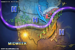
It's going to be another one of those weeks...Mother Nature is going to go through more mood swings. Temperatures are going to start off the week below normal...then, on Wednesday, we will get this surge of warm air that will bounce the daytime high up to 70 or higher. That will be followed by a drop of 20 degrees on Thursday as the temperature only gets into the 50s. And, just to make it fun, we may get to experience some severe weather midweek as the jet stream races right over top of us while on the surface the warm and cold air clash. Wonderful!

So you ask, when is it going to get warm and stay warm? That may not happen until mid-May. Sorry.

Sunday, April 10, 2011

Finally it's warm!

Finally I think we're turned the corner.  That's not to say that cool temperatures are not in the forecast, but even seasonal temperatures are not that bad compared to the past few weeks. Our normal high for mid-April should be in the upper 50s and then in the mid 60s by the end of the month.

While today (Sunday) and tomorrow will be considerably above normal temperature-wise, we will drop back to reality on Tuesday. A fairly rigorous cold front is due to cross the state Monday afternoon and that's going to bring with it some thunderstorms. Actually, we may have some left over overnight storms during the morning and then some new ones during the afternoon. Some of those afternoon storms could become a bit nasty. You will want to keep up with the forecast tomorrow, but expect to hear the sound of thunder as you go through your day. That's not a bad thing. It just means that summer is closer.

Thursday, March 31, 2011

Slow warming begins next week

So the snow Wednesday evening was really annoying, but aside from that, everyone I talked with thought it was kinda pretty.  LOL Well, sunshine and spring flowers are pretty, too and I would much rather see them than the snow this time of year.

I looks like a slow warm-up is going to begin next week.  Don't expect a warm temperature surge, but rather a gradual trend upward through the middle of the month. We may have a couple of days well into the 60s, but only one or two.

Temperatures will start to push toward normal next week. Our normal daytime high should in the mid 50s next week increasing to the upper 50s by mid-April.  It's going to be a hard crawl, but I think we can make it.  Just hang in there, little buddy.   :-)

Sunday, March 27, 2011

Warmer temperatures where art thou?

OK...enough of this already! Unfortunately, we apparently have not yet had enough, at least according to Mother Nature. I just checked out the long range models for the next two weeks and sadness has befallen me. Looks like we are going to remain below normal.

The problem we have had this weekend is that a nice cold Canadian HIGH pressure system is located to our northwest and has been pumping lots cold air over the Great Lakes. These morning lows in the mid-teens are really annoying.

Daytime high temperatures this coming week will start to trend upwards beginning mid-week, but in general we will remain below our weekly average high. I am seeing some hope for the first week of April. It looks like we could finally get up close to normal for daytime highs.  For the record, the normal daytime high during the first week of April is in the mid 50s. I can live with that, but don't bet the farm just yet.

Oh, remember last year?  If not, here's how we started off April:

April 1st - High 79
April 2nd - High 82
April 3rd - High 80

Ah...if we could only re-live those days again.  :-)

Stay warm!

Sunday, March 20, 2011

The long, long winter...this year compared to last year

I've had a lot of people ask me about this current winter. They seem think that it has gone on "forever".  ("Forever" is a relative term, of course.) Well, it has seemed to have been a long one. That being said, I figured it was time (on this first day of spring) to go back and compare this winter with last winter.  This may surprise you, but the total snowfall difference from December 1 to March 20 this winter compared to last winter is officially less than 2".

For purposes of comparison I'm going to use the official snowfall figures from the National Weather Service at Akron/Canton Regional Airport.  Of course northern Portage and Summit counties received much more snow do to lake effect, but the general pattern is the same. We just had more of it up north. (Note that, according to the Record-Courier newspaper, Dr. Thomas Schmidlin of Kent State University has measured 116" of snow in Kent so far this winter, but that's the snow belt for you.)

From December 1, 2009 to March 20, 2010 (last winter) we officially had 61.2" of snow.  For the same period this winter we had 62.9" of snow. That's less than 2" inches difference.

So, looking at the similarity in snowfall amounts, why does this winter seem so bad? There's a good reason.  This year each month (December through February) had similar amounts of snowfall. (See the chart below) Last winter, we had more snow in February alone than we did in the two previous months combined. So, while last year most of the snow fell in one month (February), this year it has fallen more evenly and consistently throughout the winter, thus making it seem that this winter has gone on forever.

So, there ya go!

                         Last Winter          This Winter

December              9.3"                      19.5"        

January                 14.7"                     18.9"

February               37.2"                     18.4"

March (1-20)        Trace                      6.1"


TOTAL                61.2"                    62.9"

Wednesday, March 16, 2011

A touch of Spring

Spring officially arrives this Sunday and it actually looks like it's going to be a pleasant day.

As expected, we turned the corner this week temperature-wise.  We are heading into a warmer period, however rain is still in the forecast.  So, generally the next week and a half should average out to be warm and wet.

Thursday, March 10, 2011

Quick update on the snow (Thursday, 4:15pm)

Rain will change over to snow around midnight tonight.  Snow will fall at a rate of about 1/2" an hour.  That should give us 2-4 inches of snow on the ground by daybreak.  This is going to be a wet snow, so even though there won't be too much on the ground, it will pack nicely and on the highways the cars driving over it will turn the snow to ice. So, things could be a bit slippery for the morning rush.


By the time the storm moves away late tomorrow we should generally see 6-8 inches on the ground with a bit more in some areas.  The National Weather Service has issued a Winter Storm Warning for heavy snow for overnight tonight and tomorrow.

Snow update (Thursday, 2pm)

(Map courtesy of www.accuweather.com)
Colder air is now moving into western and central Ohio. Temperatures will drop below freezing shortly after midnight. Rain will change to snow a few hours before that. The snow will be heavy and wet and accumulate rapidly.

I'm still looking for 2-4 inches of new snow by morning with an additional 3-5 inches during the day tomorrow. Total snow will probably end up being 5-8 inches by the time the snow trails off late Friday. Snow will be heavier to thew north and east of Akron. Snowfall may vary by several inches from one end of the county to the other. The heaviest snow may end up north and east of Ravenna.

Snow update (Thursday, 8:30am)

(Map courtesy of  http://rapidrefresh.noaa.gov)
We are still on track for snow overnight tonight. The colder air will move in and change the rain to snow probably close to midnight. I'm still thinking 2-4 inches of wet snow by daybreak with another 3-5 during the day tomorrow.

The map at left is from the National Weather Service Rapid Refresh Model and shows the tongue of snow dipping into NE Ohio. You can look at that and see why the snow forecast is so uncertain. There will be a lot of variation in snow depths within a 40 mile area north to south and east to west. This is probably going to one of those storms where "you get what you get" and your friends 15 miles away will have something totally different.

Wet snow...yuk!

(Map courtesy of www.accuweather.com)
All the rain of the last few days will change over to snow tonight (Thursday). Temperatures will be just a few degrees below freezing so that is going to make for a heavy, wet snow.  It will accumulate rapidly and could cause some problems for tree branches and power lines.

As for snow accumulations, this is the tough nut to crack.  The LOW will move over Ohio and end up someplace around Pittsburgh or Erie tomorrow morning.  As you can see on the map, there is going to be a tongue of heavier snow on the backside of this system. Snowfall amounts could vary considerably north and south of I-76 and from western to eastern Portage County.

Since this thing is so borderline, I'm going to with 2-4 inches around the area overnight tonight.  Add to that an additional 3-5 inches tomorrow, but that may be up for discussion again later today.

Wednesday, March 9, 2011

Snow...lots of it or just a moderate amount?

LOW pressure over Chicago will move up over NW Ohio during the day on Thursday and that will keep the rain and flooding in the forecast. The next element of concern comes when the colder air moves into NE Ohio Thursday night. The rain will transition into snow. The question at this point is how much snow will fall.  NWS is looking for the LOW to deepen and dump lots of snow in the region...like 6 to 12 inches by Friday evening. I'm not sure I want to jump on that bandwagon just yet. At this time I'm going to go with a more conservative 3-6 inches by midday Friday until we see if the storm system really winds up.

No matter which way you go with the snowfall totals, the temperatures will be just a few degrees below freezing and that means this is going to be a heavy, wet snow. It will accumulate rapidly and will put a lot of pressure on tree branches and power lines.  It could be a bit messy during the morning on Friday.

We'll watch this overnight and see how it looks Thursday morning.

Monday, March 7, 2011

More of the same

We seem to be stuck in this weather pattern where we have a couple of nice days with mild temperatures followed by a weather system working through the Great Lakes with rain, followed by colder temperatures and snow. Looks like that will be the case again this week. We are starting off rather mild with some sunshine. After a couple of nice days (Monday and Tuesday) we will fall back into a rainy period (Wednesday) followed by slightly colder temperatures and some flurries and snow showers.  Yawn!

Enjoy  :-)

Friday, March 4, 2011

Heaviest rain Friday night and Saturday

A couple of weather systems will affect us during the next 48 hours. The first one will move across the area today. This is a weak system and will bring some rain.  However, later tonight and during the day tomorrow and stronger LOW will be in the area and that one will tap Gulf moisture. That system will crank up the rainfall rates and, with warmer temperatures over the region, some thunderstorms are also likely. Rainfall amounts will total over an inch through the day Saturday. Obviously, with the ground so saturated, any significant amount of rain will cause additional flooding.

Thursday, March 3, 2011

More flooding is on the way

(Map courtesy of www.accuweather.com)
Here we go again...more flooding is in the forecast for the upcoming weekend.
Rain will start on Friday and continue into early Sunday morning as a couple of storm system move into the Lower Great Lakes. Since we will be in the warm sector, some thunderstorms are also a possibility for Friday night and Saturday. Rainfall amounts of .75"or more are expected overnight Friday and again on Saturday.
Bottom line is that with the ground already saturated somost of the water will run off and more flooding is a certainty.

Monday, February 28, 2011

Wet and Colder!

Overnight rainfall total at the Weather Center as of 7:30am = 1.38 inches.

The temperature dropped from 51 degrees at 6:30am to 37 degrees at 7:30am.

Saturday, February 26, 2011

And now comes rain

One thing about Northeast Ohio weather, it rarely gets dull. Less than three days after heavy snow, heavy rain is in the forecast. Here's the scenario:

Map time: 7pm Monday
Rainfall for Portage and Summit Counties
is forecast to be 1.5" or more by Monday evening.
(Map courtesy of www.accuweather.com)
Warmer air is going to push into the area on Sunday. By Monday morning a strong LOW will be located around western Lake Erie. By late Monday a second weaker LOW will be moving into the Ohio Valley. At the same time, a cold front will be sweeping across the state. (Whew!) With Monday's daytime highs in the mid 50s, some thundershowers are also a possibility.

Rainfall amounts of 1" to 1.5" will be general across the area. Combine that with the melting snow, and localized flooding is going to be a definite reality.

The rain should move out quickly Monday night and Tuesday will be mostly sunny and a bit cooler.

Thursday, February 24, 2011

Nasty Rush hour coming for Friday

Here we go! During the day today the forecast models were sort of in a state of flux as to exactly where this approaching storm center was going to go. Well, we seem to have reached a consensus...and it's not good news for the morning rush hour.

A storm system is going to move from Cincinnati up the Ohio River Valley to near Pittsburgh by morning and that’s going to give us some rather significant snow.

Rain will begin after dark. The snow will begin shortly after midnight and continue into tomorrow afternoon.

Winds will pick up about midnight as well making for a very messing situation for the Friday rush hour.

The forecast models I’m looking at at the moment are showing snowfall rates of ½ to 1 inch an hour for the morning rush along with winds of 15-25mph accompanied by stronger gusts. The National Weather Service, however, is indicating that snowfall rates could reach more than an inch an hour at times during the morning rush hour. If that occurs, it will really be ugly for the commute.

By late morning the snow will back off, but we will still pick up a few inches during the day. We’ll probably end up with 6-10 inches by Friday evening.

Tuesday, February 22, 2011

More to come

Graphic courtesy of www.accuweather.com
If you enjoyed that last round of ice and snow, we have another round coming later this week, although it looks like less ice.

Another storm system will move to our south. The best track now looks like it will go far enough south to put a heavier swath of snow across the northern part of the state. Rain might be the precipitation of choice at the beginning on Thursday. Then we're probably looking at 3-6 inches of snow Thursday night and early Friday depending upon exactly where it tracks. As things go, that's not bad.  Just enough to cause some problems.

On a warmer note, looks like about two or two and half more weeks of this before the pattern shifts and the warmer air starts to move north.  That will be around the second or third week of March.  Woo Hoo!

Friday, February 18, 2011

The tease is over

Courtesy of www.accuweather.com
Well, that's it. The tease of Spring is over. Colder air is moving into the area for the weekend and the early part of next week. Along with it will be occasional snow showers. By the end of next week we will starting to warm up again - not the 50s, but the 40s - then we will cool down again for awhile. So, Spring is not here to stay, but we will get some spring-like temperatures from time to time along with rain and snow. Yeah, this is the time of year it gets old and drags on...and on...and on.

Enjoy as best you can!

Sunday, February 13, 2011

40 degrees? It's been awhile...quite awhile.

The last time we were above 40 degrees here in the Akron area was New Years Day.  Well, we did it today! The thermometer here at the Weather Center hit 40 degrees late this morning.  Unfortunately, yesterday when we hit the mid 30s it didn't feel quite so warm because of the wind chill.  The stiff northerly breeze we had was knocking 10-12 degrees off the "feels like" temperature. It's still going to be breezy the next few days, but it will also be a bit warmer so, it's sort of a trade-off.

The really good news will arrive on Wednesday, Thursday, and Friday when we hit daytime highs in the 40s and even the 50s. By Friday afternoon (probably well before that) you can say good-bye to the snow cover, except for those "snowbergs" at the edges of parking lots and driveways.


The two maps below show snow cover across the Northeast U.S.  The top map shows how much snow is on the ground this morning (Sunday). The bottom map shows the forecast snow cover for Wednesday afternoon.  Note that by Wednesday most of the snow in southern and central Ohio will be gone with only an inch or so on the ground in the northeast. Getting rid of the snow to the south will help our temperatures warmup since the mild air coming up will not have to blow over an icy cold snow pack and thus cool down on its way northward.


Now, before you get too excited, let me note that another surge of cold air is set to arrive next weekend, but at least daytime highs will still be a bit above freezing...probably mid to upper 30s.  


Sunday morning snow cover

Forecast snow cover for Wednesday afternoon


Friday, February 11, 2011

It's coming...it's coming!

Map courtesy of www.accuweather.com
It's been a long time since we have been significantly above freezing here in NE Ohio.  January 18th we hit 37 degrees and that's the best we've done recently.  Well, the good news is that warmer temperatures are on the way. Beginning Wednesday we should finally bounce into the 40s and actually stay there for daytime highs through the weekend. In fact, much of the nation from the plains to the east coast is going to warm up.

Now, don't get too excited.  Winter is not over yet, at least not around the Great Lakes. We'll still have temperature swings above and below freezing, but prospects for extended periods of very cold weather diminish as every day passes.  I guess we could say that here is light at the end of the tunnel.  We're not there yet, but we are making progress.

Sunday, February 6, 2011

Good news if you are tired of the snow

If you've had enough of the snow for awhile, there's good news. Scratch that potentially big snow storm mid to late week.  Isn't gonna to happen. I don't know too many people who will be upset about that.  This continuous cold and snow is starting to get old, although it was nice to see the sun shining on Friday and Saturday. Yeah, that felt good! It is going to get quite cold the end of the week again, but a nice little warm-up will beging next week.

As noted above, after we get past this coming week, we will start to warm up a bit.  That means going above freezing a little more often.  While winter will be over in the south, here in the lower lakes, we will likely be going back and forth, but at least it's back and forth and not down the tubes. I can handle more snow and cold in short spurts as long as we get some sunshine and warmer temperatures in-between.

Enjoy your week!

Saturday, February 5, 2011

Adjusting the timing for weekend snow

The first snow system heading into the region slowed down a bit, so the snow did not arrive overnight.  It's running a few hours late and should be in the area by noon today (Saturday).  We should get 3-5 inches of snow out of this system before the snow ends overnight.

A second snow system will move into the area overnight Sunday and hang around Monday.  This one will leave behind another few inches by late Monday.

Basically, nothing exceptional...just winter snow.

Friday, February 4, 2011

It ain't over yet...just wait till next week!

If you think this week was cold and snowy, next week could be the worst week of the entire winter. We're talking the coldest air of the season and perhaps another big snowstorm.

We'll have a light weight snow system move through the area overnight tonight (Friday) leaving us with just an inch or two.  Sunday night and Monday morning a second snow system will likely leave behind 3-6 inches. Then the big stuff arrives.

Colder air, probably the coldest of the season, will arrive by late Tuesday or early Wednesday. A storm system is expected to develop over Texas and move along the Gulf coast on Wednesday. The LOW will then shoot northeast into the Ohio/Tennessee Valley. If it does what the model expects it to do, it will be snowy, windy, and very cold around these parts during the Wednesday/Thursday time period.  Then, behind the wind and snow, COLD!  Like Friday morning lows could be well below ZERO.

It's not on the maps yet. The storm hasn't developed. But, you will want to keep up with forecasts next week. It could be another week of "fun in the wonderful world of weather".

Oh...wait! Before I go, I do want to point out that after we get past this mess next week, we will turn the corner. A significant warm-up is going to begin the last week of February.  :-)

Wednesday, February 2, 2011

An early Spring?

Looks like neither Punxsutawney Phil nor Buckeye Chuck saw their shadow today.  That means an early Spring is coming.  Well, after December and January I'm ready for that.  For the record, we should pick up 7 degrees on average for our daytime highs this month. We start off with an average high of 34 and end up at 41.

BUT, WAIT!  THERE'S BETTER NEWS AHEAD!
We have another cold surge coming next week, but after that we are going to turn the corner for awhile.
According to our friend, forecaster Joe Bastardi over at AccuWeather, a big warm-up is on the way for the last half of February.  The forecast models are showing the cold air getting stuck up north while a more zonal pattern develops across the continental U.S. Once we get past Valentine's Day, we should all start to feel "warm all over"....and that will make you and me feel better.

After the storm...What a mess!

Well, we got the ice just as we thought.  Temperatures this morning warmed up nicely to around 40, but that didn't really help much,  The rain falling on the already accumulated ice just made things that much more slippery.  Now temperatures are about to hit the skids, so all that stuff is going to re-freeze.  Oye!

Anyhow, today temperatures will take a dive.  Colder air is currently moving in and the winds are picking up.  The icy glaze we have out there is going to hang around for a while.

Later today, we will probably see more snow...not much...just an inch or so.  Enough to make things just a tad more complicated.

So, if you are going out...be careful.  If you don't have to, stay in. Meanwhile, I'm walking to go out to the kitchen to make me a nice breakfast of scrambled eggs, bacon, and pancakes!  :-)

Tuesday, February 1, 2011

Winter storm update (Tuesday morning)

Well, some ice moved into the southern region last night.  That caused lots of school closings. Not sure why everything up north closed down today. Tomorrow will be a different story.  Today is not going to be that exciting.

Anyhow, here's what's up for the next 36-hours...

During the day today we will have occasional flurries and snow showers. Not much accumulation today...perhaps an inch or so.

After 5pm today freezing rain will start to move into the areas south of Akron and gradually move northward.

By 2am tomorrow morning (Wednesday) most of the area should be covered with 1/4" of ice.

By 8am 1/2" or more of ice accumulation is likely.

The ice, combined with sustained winds of 15mph with stronger gusts, will likely cause numerous power outages overnight and tomorrow morning.

Things will settle down by tomorrow evening, however temperatures will plummet from around freezing in the morning into the lower 20s by evening.  Brrrrrr!

Hey, the Friday forecast looks good:  Mostly sunny.  High 24.

Woo Hoo!

Enjoy!   (as much as you can)

Monday, January 31, 2011

Winter Storm Update (Monday evening)

A "WINTER STORM WARNING" will be in effect overnight tonight into Wednesday evening.

Map courtesy of www.accuweather.com
We will start to see the first effects of this winter weather event overnight tonight as snow moving across Indiana this evening reaches eastern Ohio. We will likely see 3-4 inches of new snow by daybreak.

Tomorrow snow will continue off and on with a total snow of 4-6 inches by evening.

The snow will change to freezing rain Tuesday evening (sometime between 7pm and midnight) and continue overnight.  By Wednesday morning total snowfall will be 5-7 inches with an ice accumulation of 1/4 to 1/2 inch. It will also become windy overnight.

The morning commute on Wednesday will be quite nasty with freezing rain and snow and the likelihood of downed power lines and tree branches.

During the morning Wednesday the freezing rain will change over to all snow with a total snowfall of 7-10 inches by evening.

On top of the snow, freezing rain, and wind temperatures on Wednesday will fall from near 30 in the morning into the lower 20s by evening.

Looks like a good one...stay home and enjoy!

Storm timing

Obviously, subject to change, but based on the current models, here's what I see happening in the Greater Akron area:

Light snow will begin tonight (Monday) after 9pm and accumulate 1-3 inches by morning.

Flurries and snow showers will fall during the day tomorrow.

Snow will begin again tomorrow (Tuesday) after dark.

Snow will mix with or change to freezing rain between 9pm and midnight. It will also become windy overnight.

By 3am the entire area should be getting freezing rain.

By 9am, ice buildup will range from 1/4" to 1/2".

I will update the times and totals as the storm gets closer and the exact track is determined.

Monday morning storm update

Things are still on track for a big weather event here in NE Ohio Tuesday night and Wednesday morning. There's not much showing up yet on radar out in the plains, but we should see things come together today and then move into the Ohio Valley.

For the Greater Akron area is looks like snow will begin Tuesday evening and continue overnight with freezing rain mixed in.  It's also going to get a bit windy. By Wednesday morning areas that see mostly snow will have 4-8 inches on the ground.  Most areas will see a mix of snow and freezing rain.  The freezing rain may produce 1/2" to 3/4" of ice.  If that actually happens, it will cause considerable damage to  power lines and trees.

The National Weather Service currently has us under a Winter Storm Watch.  That will be likely be  upgraded later today to a warning.

Sunday, January 30, 2011

It shouldn't have to be this difficult

Why is it that we most always are on the edge of this or that?  The latest computer models are now trying to move the center of the storm right over top of us early Wednesday morning.  If that happens, warmer air will infiltrate parts of the region changing the snow and freezing rain to all rain for a period of time.  It's possible, as I hinted earlier, that the region could be split. It all depends upon what Fido decides to do.  (If that doesn't make sense to you, read my earlier posts.)

Map courtesy of www.accuweather.com

So, let me try to make some sense here.  First of all Monday night into Tuesday morning we will collect a few inches of snow (1-3) as a surge of warmer air moves through.  Tuesday night the joy begins with snow and freezing rain.  We will probably stay snow and freezing rain during most of the night.  If there is a changeover to rain it will occur just before rush hour.  The areas that remain all snow could see 6-8 inches by daybreak.  Where freezing rain occurs the snow total will be less, but ice buildup of 1/2" of more will be possible. That will likely cause tree branches to break and power lines to go down.  If a changeover to rain occurs, it will be during the morning hours, with snow returning in the afternoon.

Anyway you cut it, it's going to be a bit ugly Tuesday night into Wednesday morning. Keep checking back.  As the storm starts moving out of the plains we will get a better idea where it wants to go.

Oh, by the way, the groundhog will not see his shadow on Wednesday. Woo Hoo!  The end of winter is near!  (Yeah...right.)

If it really gets this bad...it will be really bad

Checking out the Sunday morning forecast models.  This is scary.  Seriously...if things work out the way the models are predicting Wednesday is not going to be a day to be out and about. Here's what it looks like as of this morning.  Now, keep in mind that winter storms are like pets.  Sometimes you expect them to do one thing and they do something else...like "Come here Fido."  So, he gets up and walks over to the corner and lies down instead.

We will start off with a little teaser Monday night...like an inch or two by Tuesday morning. Nothing to write home about.  Then, after dark on Tuesday, the fun begins.

Scenario #1 - All Snow
The line between snow and ice will be pushing close to the Akron area Tuesday night and Wednesday.  In fact, the area could get split.  But, let's assume we have all snow. In those areas the snow will begin after dark on Tuesday.  By Wednesday morning some areas would have 6" to 8" of new snow on the ground.  The overnight snowfall rate could be 1"+ an hour at times. Snow would continue on Wednesday with several more inches falling along with strong, gusty winds and blowing and drifting snow.

Scenario #2 - Snow and Ice
This is the one that is really frightening.  If this occurs, the area could be shut down for a period of time.  The models are printing out from 1/2" to over 1" of ice buildup overnight Tuesday.  That much ice would cause havoc on tree branches and power lines, not to mention roadways. With this scenario, snowfall will  be cut back considerably to less than 6" total by Wednesday evening. Nonetheless, the area would become immobile by Wednesday morning.

Whichever scenario develops, we should see things back off by late in the day Wednesday.  With Lake Erie frozen, we won't have to worry too much about lake effect.  That's the one good thing in the forecast.

Until we can get a more definite track on the storm, I would plan for the worst.  Stock up on food and plan for power outages. It's the millenium so it won't be that long until you can get back out (not like the 50s when people got stuck in their houses for a week at a time), but, then again, you may not want to go out for awhile.

More later...

Saturday, January 29, 2011

Winter storm on the way

   Next week is looking rather nasty. Early in the week a storm system will move out of the Rockies, down into Texas, and then up the Ohio Valley. For us that means snow with perhaps a bit of sleet and freezing rain mixed in.
Map courtesy of www.AccuWeather.com
   Based on the current projections, the fun should begin in NE Ohio after midnight on Tuesday and continue into the day on Wednesday.  Forecast models are showing between 4-10 inches of snow, depending upon whether or not we mix in the freezing rain and sleet.  As always, the exact track of the storm will make a difference. On the current track the Greater Akron area should get lots of snow, but if the storm moves a bit farther north, then we will get the mix.  We won't really know until it happens. Anyway you look at it, overnight Tuesday and during the day Wednesday won't be so nice.
   More as we know it.  Meanwhile, plan ahead.

Sunday, January 23, 2011

Below ZERO for the first time in nearly two years!

Wow!  What an exciting morning it was Saturday (22 January).  The temperature here at the Weather Center dropped to -4 degrees! This is the first time we dropped below zero since 5 February 2009.  That morning was also a -4 degrees.

Actually January and February of 2009 both had some rather cold days in them. January was the kicker though.  Remember the two mornings of January 16th and 17th when the temperature drooped to -14 degrees?  Now that was crisp!

Well, nothing like that is in our immediate future, although there is a hint in the models that we could get another really cold push of arctic air in February. Nothing for certain yet, but our friend Joe Bastardi over at AccuWeather is getting all excited.  We shall see.  Meanwhile, keep the dogs (or your cat) nearby just in case.

Enjoy!

Sunday, January 16, 2011

A "Three Dog Night" is on the way

If you love cold winter weather, you'll enjoy the next few weeks.  Looks like the coldest air of the winter is heading our way and will likely hang around for a while, nixing our anticipation of a significant January thaw.  Looks like that will have to wait until very late this month or sometime in February.

How cold are we talking?  Well, I don't see us going above freezing until the last few days of the month at the earliest. Daytime highs through midweek this week will be in the 20s. Next weekend daytime highs will be in the teens.  After a few warm nights early this week overnight lows will drop into the teens and single digits for a while. Oye!
Bomber resting comfortably on my electric blanket

Oh, about the dogs...see the story goes that the Eskimos on really cold nights would bring the dogs in to the igloo to sleep with them and keep them warm.  So, a three dog night was a very cold night...it took three dogs to keep warm.

I sleep with my cat Bomber and an electric blanket, so I'll be OK.  Hope you will be, too.

Sunday, January 9, 2011

Well, it's cold

Yep.  Let's start out with the obvious.  Arctic air has moved into Ohio. It's going to remain here for awhile...like the next two weeks.  Then as we get to the end of the month, the arctic blast will move north and warmer air will push into the region.

Our normal high for the next few weeks is in the low 30s. This is what is commonly referred to as "the dead of winter." We will be well below that normal high this coming week (January 9-16), then we'll probably start to bounce around again the week after that. I foresee some pretty cold overnights in our future, especially next week when we could hit the single digits. You might need to bring the dog in to sleep with you.

(Map courtesy of www.accuweather.com)
Of note this week will be LOW pressure system moving across the state on Tuesday (see map). This is going to be an interesting storm because as it moves into Ohio it will eventually merge with a storm currently moving across the south. The new storm will then head north dumping snow in New England.  As this happens, our winds will shift to the NW kicking in lake effect once again. Looks like we can expect 3-6 inches of snow from Tuesday afternoon into Wednesday morning.  Then later Wednesday into Thursday the lake effect develops.  Sounds like a typical January here in the lower Great Lakes.

BTW...as I noted in earlier posts, I'm measuring the rest of the winter against December's cold and snow. While we are going to be cold for a few weeks and get some snow as well, I still don't think we're going to beat December.

Winter sports fans...enjoy!

Sunday, January 2, 2011

Welcome to January 2011

Well, here we are...2011.  The spring-type weather (warm temperatures and rain) have left us and it's back to normal January type weather. Our normal daytime high for January ranges from 32-34. We will be hanging around that mark for the much of the month.  We will have a few warm spurts and a few colder ones, too. But, I suspect the prolonged cold...3 consecutive weeks below freezing...are gone for awhile.

As for snow, there will be some.  We're not done yet.  In fact, winter is only a few weeks old.  With Lake Erie cooling down, the temperature contrast between the water and the air is less and that will dampen Ole Man Winter's lake effect efforts. What we have to watch for, however, will be any storm system moving from the southwest or the Gulf coastal area.  If it decides to come up the west side of Appalachians, standby.  That could be a scenario for heavy snow in eastern Ohio.

So, basically, I think that after the unusually cold and snowy December we just had (the temperature was 6.6 degrees below normal and well over two feet of snow fell in the northern parts of Portage and Summit counties) January will likely produce a much more normal winter scenario.

Winter sports enthusiasts, enjoy!