Wednesday, June 12, 2013

Wednesday Forecast, June 12, 2013

FLOOD WATCH WEDNESDAY NIGHT UNTIL THURSDAY AFTERNOON!
Heavy rain will move into the area Wednesday evening and overnight producing from 1½ inches to over 2 inches of rain by midday Thursday. Some locations could see rainfall totals approach 3 inches. There could also be some periods of strong, gusty winds overnight.


Wednesday,
June 12


A mix of clouds and sun with evening showers and storms. Some storms could become heavy.
High near 80


At Night


Showers and thunderstorms with heavy rainfall likely.
Low 65


Thursday,
June 13


Lots of clouds with some morning showers and storms.
High 70-75


Friday,
June 14


Partly to mostly sunny.
High around 70


Saturday,
June 15


Mostly sunny.
High in the mid 70s

Tuesday, June 11, 2013

Tuesday, June 11 forecast


Tuesday,
June 11


Variable cloudiness with a passing morning shower possible, followed by a bit of sun in the afternoon.
High 75


At Night


Lots of clouds.
Low 63


Wednesday,
June 12


A mix of clouds and sun with evening and overnight showers and storms.
High near 80


Thursday,
June 13


Partly cloudy with some morning showers and storms.
High 73

Friday,
June 14


Partly to mostly sunny.
High 70-75

Thursday, March 21, 2013

A change is gonna come...maybe?

Had enough?  I have! We have been stuck in an upper level weather pattern that has been insistant on keeping very cold air over the Great Lakes for the past several weeks. This week's temperatures with highs around 30 and lows in the 20s is normal for JANUARY! We should be seeing daytime highs of 45-50. That's normal. I guess that's why we live in northeast Ohio.  We just love the changing seasons.  LOL

Remember last year? Yeah, a lot of people do. I've heard folks reminiscing about it all week. Last year, the warmest day in March was the 22nd...83 degrees! In fact the whole week had temperatures in the 80s. Dang, I miss that.

This weekend's storm will likely remain south of our area.
(Map courtesy of AccuWeather)
OK, well here's the gig. We have a big storm that's going to move across the plains and the eastern U.S. this weekend. (See map) It looks like the bulk of the snow is going to remain south of the Greater Akron area meaning we will only get a few inches. Next week is going to continue to be unseasonably cold with highs in the 30s and 40s. Then comes April.

The current long range forecast models are indicating a change beginning to occur right after Easter. If this pans out we should see a transition during the first week of April. That will mean a switch to warmer daytime highs. We will still probably experience a day or two of cold, but at least it will be a quick shot. Then during the second week we could actually begin a legitimate spring warmup.

Woohoo!

It's still early and it's still a couple of weeks away, but if the models are correct at least there's light at the end of the tunnel.

Sunday, January 27, 2013

One strange week coming up

This is going to be a bizarre weather week. It begins this morning (Sunday) with sunny skies. Then overnight tonight a surge of warm air begins to move in. The warmer air will first arrive in the upper atmosphere. So, with the overnight temperatures at the surface being below freezing, frozen precipitation is likely. That means snow, freezing rain, and sleet. Oi! It could be an interesting rush hour Monday morning.


After that, very much spring-like temperatures will invade the region with daytime highs in the 50s on Tuesday and Wednesday.


The mild temperatures will be short-lived, however, as cold air plungers down from the Arctic on Thursday. Thursday will see daytime highs 20-30 degrees colder than Wednesday as the mercury only reaches into the mid 20s.


So, get ready for it. It's gonna be a fun ride!

(Graphics courtesy of AccuWeather)

Friday, January 11, 2013

The January Thaw Followed by Arctic Cold

Our January thaw will peak tomorrow (Saturday) with the mercury hitting around 60 degrees during the afternoon. On Sunday we will be about ten degrees cooler, then "Whoa!" Back to reality as we return to normal daytime highs in the lower 30s for the first part of next week.

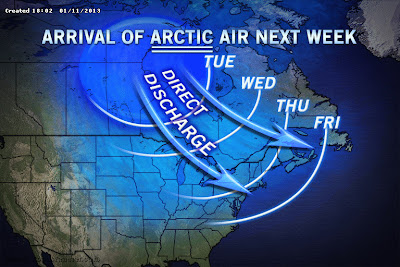
(Courtesy of AccuWeather)

OK, that's not so bad. But, wait till later next week. As you can see by the map above, a blast of pure arctic air will arrive during the day on Wednesday. By Thursday and for the next few days we could see temperatures only peaking around 20 with nighttime lows well down into the single digits. Yeah. That's more like winter.  Brrrrrr!

At the moment, there don't appear to be any major snowstorms in our future, however with the arrival of the arctic air, we could perhaps crank up the Lake Erie snow machine again. We'll have to keep an eye on that. 

So, enjoy the warm air this weekend. When the cold air arrives next week, it will likely hang around through the first couple of weeks of February.  

 - Bob

Tuesday, December 25, 2012

Winter Storm WARNING for Wednesday


WINTER STORM WARNING FOR WEDNESDAY!
Snow will begin Wednesday morning and continue until Thursday morning. New snow by Thursday morning will total 8 to 10 with lots of blowing and drifting expected on Wednesday and Wednesday night. The heaviest snow should fall during Wednesday afternoon and evening.

Monday, December 24, 2012

Snow and more snow!

   A very active weather week is in store for the area. The good news is that Christmas Day will be nice for your travels. The bookends around it, though, not so nice.
   This is Christmas Eve and an area of light snow will be heading into the region during the afternoon. It may even mix with rain for a while and then some freezing rain after dark. But, all in all, it won't amount to too much of a problem for you. (See map below)

Map courtesy of AccuWeather
   Christmas Day should see a mix of clouds and sun during the day.  As we head toward the later part of the day, the clouds will thicken as a major winter storm heads up from the south. Current forecasts indicate that the snow should begin early on Wednesday morning and continue through the day and into the night. (See map below) This has the potential to be really big, but at the moment I'm looking at 5" to 8" generally by Thursday morning. Some forecast models are showing more than that, but I don't want to go there yet. We'll wait and see how this thing develops. 

Map courtesy of AccuWeather
   We should settle things down a bit on Friday, but another system will head our way for the weekend. 

   Whew! Busy times!  Nothing at all like last winter.

   Enjoy...and Merry Christmas from us here in the Weather Center!