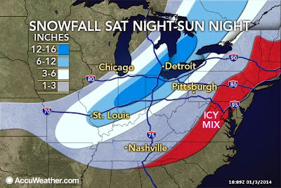
 As noted in previous posts, some extremely cold air is on the way for the beginning of next week. But, before that, we have another round of snow to deal with. A snow system will move up the Appalachians on Sunday dumping 4-8 inches of new snow in the Greater Akron area.
(See the map for the snowfall track.)
Following the snow, the cold moves in on Monday.
Temperatures Monday will drop all day. The highest readings will be in the early morning. By Monday evening the actual air temperature will be ZERO or below with wind chills around -30.
Tuesday morning the air temperature will be around -12 with wind chills in the minus mid-30s. We will warm up to near ZERO on Tuesday, but wind chills will still be around -20.
Wednesday morning should be a tad warmer by comparison. The actual air temperature will be around -7 with wind chills in the minus mid-20s. After that, we start to warm up.
Stay warm and stay safe!
No comments:
Post a Comment