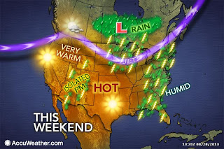
 Things are still a little shaky, but the Labor Day weekend weather is starting to come into better focus.
The weekend will start out dry and warm. Saturday may end up being the best day of the 3-day weekend. The only complaint will probably be that it's going to be quite muggy. The daytime high will be in the mid 80s.
 |
| [Maps courtesy of AccuWeather] |
That's something that is going to be hard to pin down. My advise to you right now would be go ahead and plan your weekend gigs. If a shower or storm rolls over your house, just hope it keeps on moving and doesn't' stall out.
Labor Day itself will be much like Sunday, except a little cooler and maybe with more showers and storms do to the proximity of the cold front.
After the holiday, much cooler and refreshing air will move in NE Ohio. Daytime highs Tuesday through Friday will likely be in the lower end of the 70s and will perhaps not get out of the 60s for a day or two.
No comments:
Post a Comment